WRWA HABs Watchers Master Dashboard
Temperature and precipitation load the last 72 hours from the Open-Meteo archive API, with the Open-Meteo forecast endpoint as an automatic fallback. Flow loads from the modern USGS Water Data API using the page-access timestamp. Precipitation displays in millimeters with a more sensitive scale.
Today’s HABs Watcher Field Priorities
- Check live weather and flow before fieldwork.
- Visit assigned sites only when conditions are safe.
- Photograph suspicious conditions from land.
- Avoid all direct contact with suspicious water, scum, foam, or mats.
- File a report for every site visit, including no-bloom observations.
- Use the WRWA Reporting Tool first.
- Use the fallback email form only if the live tool is unavailable.
Current Live Conditions Snapshot
API: Open-Meteo archive endpoint /v1/archive for the last 72 hours of
temperature_2m and precipitation, with the forecast endpoint
/v1/forecast (past_days=3) as an automatic fallback. Hourly values are
keyed in the site time zone (America/New_York).
API: modern USGS Water Data OGC endpoint /collections/continuous/items. It requests discharge parameter 00060 for USGS-01371500 around the visitor’s page-access timestamp, then uses /latest-continuous/items as a fallback.
Data Limitations
- Weather and discharge data are screening context only.
- Remote sensing can support review but does not confirm toxicity.
- Visual observations require review and appropriate reporting.
- Official HAB status and public health determinations come from NYSDEC/NYSDOH or official NYHABS channels.
- WRWA volunteers should not issue independent regulatory closure or safety declarations.
Field Prep & Decisions
Sector Quick Reference
| Sector | Region | Core Weekly Sites | Caution | Details |
|---|---|---|---|---|
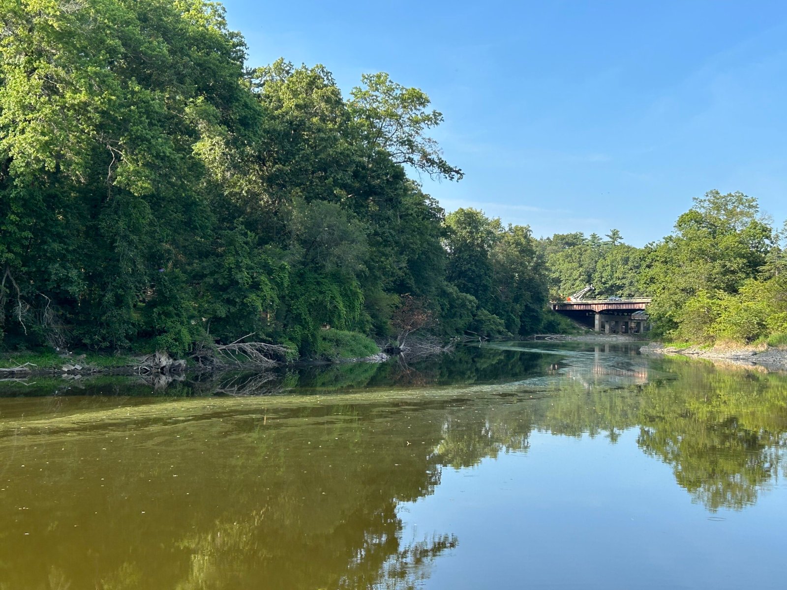
| 1 — Lower River & Impoundment | Ulster · Highest priority | Sturgeon Pool Access, Perrine’s Bridge Park, DEC Boat Launch – Springtown Rd (Rosendale) | Severe recurring bloom history at Sturgeon Pool | View Details |
| 2 — New Paltz High-Recreation | Ulster | Hand Launch – Plains Road, Sojourner Truth Park, Ulster County Fairgrounds Launch | Recurring public-health concern in low-flow periods | View Details |
| 3 — Gardiner Hydrologic Sentinel | Ulster · USGS 01371500 | Old Ford Road Access, Cartop Boat Launch – Springtown Road | High-energy mainstem; hydrologic indicator zone | View Details |
| 4 — Shawangunk Transition | Ulster | Popp Memorial Park | Downstream dam blocks linear navigation | View Details |
| 5 — Walden & Montgomery Structural Pool | Orange | Marcus ‘Mickey’ Millspaugh Park, Twin Islands Fishing Park, Riverfront Park, Benedict Farm Park, Pleasure Ground Park | Low-head dam hazard; stagnant nutrient-trap pools | View Details |
| 6 — Mid-Upper Catchment | Orange | Thomas Bull Memorial Park Launch | Steep, slippery clay slope after storms | View Details |
| 7 — Upper Basin Black Dirt | Orange · NJ Line | Oil City Road Boat Launch / Winding Waters Trail | Intense agricultural nutrient loading; persistent seasonal blooms | View Details |
Wallkill River Watershed Map
File a report for each visit — including negative (no-bloom) reports. Submit observations, photos, and site details directly through the WRWA Reporting Tool.
If the embedded tool loads slowly on mobile, use the full-screen link above (“Open Full Tool”).
Sectored Wallkill River map (hosted on roberthowe.org) overlaying HAB report history with prioritized access-site data across the seven monitoring sectors. If the embed does not load, use “Open Full Map.”
If the embedded map loads slowly on mobile, use the full-screen link above (“Open Full Map”).
Program Objective, Mission & Scope
The mission of the Wallkill River Watershed Alliance (WRWA) Harmful Algal Bloom (HAB) Monitoring Program is to safeguard public health, protect aquatic ecosystems, and enhance environmental literacy across the Wallkill River corridor through systematic community science observation, rigorous digital documentation, and coordinated data mobilization. By training community volunteers and interns to function as skilled environmental analysts, the program bridges operational gaps in regional water quality tracking, ensuring local observations are rapidly translated into actionable data for the New York State Department of Environmental Conservation (NYSDEC) and the public.
Reach-based surveillance network identifying and reporting suspicious cyanobacterial blooms within 24 hours of emergence.
100% compliance with NYSDEC trained-user photo-documentation and spatial tracking protocols.
Cultivate long-term place-based bonds, converting passive concern into active ecosystem governance.
Synthesize visual datasets with real-time meteorology (Open-Meteo) and hydrology (USGS) to enrich the regional archive.
- Weekly qualitative visual tracking at the 21 prioritized watershed access locations across Orange and Ulster Counties.
- Paired multi-scale digital photography (close-up and wide-angle contextual views) logging surface anomalies.
- Real-time geospatial coordinate logging at the precise physical location of the field observation.
- Submitting verified observations through the Survey123-based NYHABS Trained User Form under the WRWA organizational profile.
- Populating the internal WRWA tracking archive and decision-support databases to optimize coordination.
- Independent laboratory toxicological analysis or microcystin toxin quantification.
- The collection or transport of physical water, scum, or mat samples by monitoring personnel.
- Unilateral issuance of official regulatory health warnings or waterbody closure mandates.
- Independent public declarations regarding the safety, closure, or official toxic status of any watershed site.
Intern Onboarding
Welcome to the WRWA HAB Monitoring Team. This summer, your field operations provide critical surveillance across the Wallkill River watershed, acting as an early warning system to protect public health and support state-level water quality planning.
- Official Program Kickoff: The mandatory pre-season field alignment workshop and orientation takes place on Wednesday, June 3, 2026. Attendance is required to verify field kits, test digital reporting links, and standardize tracking methods.
- Weekly Tracking Cadence: Visit your assigned monitoring locations at least once per week, maintaining a consistent day and time to ensure data comparability.
- Comprehensive Data Mandate: File a report for every site visit. A negative report (no bloom observed) is as critical to the state dataset as logging an active bloom — it documents baseline conditions over time.
- Field Attire & Gear: Rugged slip-resistant footwear, sun protection, high-visibility identifiers, and a fully charged smartphone with location services enabled. An approved personal flotation device (PFD) is required near unstable launch ramps, steep banks, or deep channels.
Your safety is the absolute priority. Cyanobacterial blooms can produce dangerous toxins (microcystins, anatoxins, saxitoxins) posing severe physiological risks to humans and animals.
- Zero-Contact Mandate: All tracking is strictly non-contact and land-based. Never step into suspicious water, wade through scums, or touch floating mat material.
- Exposure Pathways: Accidental ingestion, dermal contact, or inhalation of aerosolized spray/foam generated by wind or water turbulence.
- Symptom Awareness: Watch for skin rashes, eye/ear/throat irritation, severe nausea, vomiting, diarrhea, asthma-like respiratory difficulty, dizziness, or tingling in the extremities.
- Decontamination & Deferral: If contact occurs, immediately flush skin with clean water and notify your coordinator. Discontinue operations and seek medical attention if symptoms persist. Defer assignments if you have open wounds or cuts until fully healed.
- Lightning or unsafe weather develops.
- Banks, ramps, rocks, or slopes are unstable or slippery.
- Water is fast, high, or difficult to safely approach.
- Suspicious scum or foam blocks safe access.
- Private property boundaries are unclear.
- The observer has open wounds, illness, injury, or exposure concerns.
- A pet or person may contact suspicious water.
Launch ramp sits directly south of a dangerous low-head dam hazard. Maintain distance from the northern property edge; do not launch or navigate watercraft through this reach.
Bounded by a downstream dam that completely blocks linear river navigation. Conduct assessments strictly within designated park boundaries; avoid adjacent private parcels and steep retaining walls.
Steep steps and slippery clay slope conditions become highly hazardous after storm events. Exercise extreme caution when measuring indicators from these perimeters.
Watershed Monitoring Sectors Matrix
[NJ State Line]                                                            [Hudson River Confluence]
   Sector 7  ==>  Sector 6  ==>  Sector 5  ==>  Sector 4  ==>  Sector 3  ==>  Sector 2  ==>  Sector 1
 (Upper River)  (Mid-Upper)  (Walden/Mont.) (Shawangunk)    (Gardiner)     (New Paltz)    (Lower River)
Sectors group the 21 prioritized access points by geographic reach, hydrologic conditions, and historical bloom vulnerability across the 60+ river miles within New York State.
Core Weekly Sites: Sturgeon Pool Access 1306STU0453A, Perrine’s Bridge Park WALK-5.0, DEC Boat Launch – Springtown Rd (Rosendale).
Hydrology: Slow-moving, deeply impounded downstream zone with limited flushing and long water residence times.
Historical HAB Profile: Highest-priority zone in the watershed. Sturgeon Pool shows a severe recurring bloom history, with multiple confirmed cyanobacteria events logged consistently 2016–2025.
Core Weekly Sites: Hand Launch – Plains Road, Sojourner Truth Park WALK-11.4WALK-11.6, Ulster County Fairgrounds Launch.
Reference-Only: New Paltz Golf Course WALK-9.2 (visual access only, no public launch infrastructure).
Pending Verification: Nyquist-Harcourt Wildlife Sanctuary (boat access configuration and launching terms require final field verification).
Hydrology: Moderate-flow mainstem flanked by active recreational corridors, boat rental operations, and public parks.
Historical HAB Profile: Recurring public health concern. Multiple high-toxin and confirmed visual blooms documented during the low-flow periods of 2015, 2016, and 2022.
Core Weekly Sites: Old Ford Road Access, Cartop Boat Launch – Springtown Road.
Reference-Only: Jellystone Park Gardiner (restricted private campground; background reference checking only).
Hydrology: High-energy mainstem directly influenced by the Shawangunkill tributary confluence, monitored continuously by the USGS 01371500 Gardiner stream gauge.
Historical HAB Profile: Hydrologic indicator zone; tracks initial upstream nutrient loading trends before water transitions into downstream slower reaches.
Core Weekly Sites: Popp Memorial Park WALK-24.1WALK-25.3.
Hydrology: Low-gradient channel bracketed by local agricultural operations and structural check-dams.
Historical HAB Profile: Popp Memorial Park is the sole municipally managed public access in this reach with a confirmed historical footprint of late-summer bloom stagnation.
Core Weekly Sites: Marcus ‘Mickey’ Millspaugh Park, Twin Islands Fishing Park WALK-29.3, Riverfront Park WALK-29.9, Benedict Farm Park, Pleasure Ground Park WALK-32.6.
Pending Verification: Veterans Memorial Park (Walden), Bradley Park (Walden) — direct river access points unconfirmed.
Hydrology: Highly altered zone dominated by low-head dams, old industrial millponds, and stagnant pools acting as nutrient traps during hot weather.
Historical HAB Profile: Multiple confirmed high-toxin events logged at the Twin Islands and Riverfront Park launches during the intense regional drought windows of 2016 and 2018.
Core Weekly Sites: Thomas Bull Memorial Park Launch WALK-44.4.
Hydrology: Broad, meandering mainstem channel directly draining low-velocity agricultural plains.
Historical HAB Profile: Critical zone for capturing initial biomass accumulation and nutrient-rich flows moving downstream from the upper basin.
Core Weekly Sites: Oil City Road Boat Launch / Winding Waters Trail WALK-60.1.
Hydrology: Low-gradient channel cutting through the intensive muck-soil Black Dirt agricultural region near the New Jersey state line.
Historical HAB Profile: Intense agricultural nutrient loading (phosphorus and nitrogen inputs). High water temperatures and low summer flow velocities create persistent seasonal bloom conditions across this reach.
Remote Sensing: Copernicus Code Library + Tutorial
Embedded node targets the Sturgeon Pool reach centerpoint (41.8436, -74.0426). On mobile, prefer the external launch link if the embedded map causes device latency.
Chlorophyll and sediment visualization.
Open ScriptLook-alike screening.
Open ScriptRed-edge chlorophyll screening.
Open ScriptSeparates waterbodies from surrounding terrain, isolating the river channel footprint so terrestrial vegetation does not warp algae calculations.
//VERSION=3
// NDWI Water Mask for Isolating Watershed Flowlines
function setup() {
  return {
    input: ["B03", "B08", "dataMask"],
    output: { bands: 4 }
  };
}

function evaluatePixel(samples) {
  // NDWI using Green (B03) and Near-Infrared (B08)
  let ndwi = (samples.B03 - samples.B08) / (samples.B03 + samples.B08);
  if (ndwi > 0.1) {
    // True water signature: solid blue
    return [0.0, 0.35, 0.9, samples.dataMask];
  } else {
    // Non-water landmass: dark grey terrain overlay
    return [0.05, 0.05, 0.05, samples.dataMask];
  }
}
Isolates red-edge spectral bands to estimate surface chlorophyll-a density — a digital screening tool for potential bloom formations.
//VERSION=3
// NDCI Chlorophyll Screen for HAB Hotspot Identification
function setup() {
  return {
    input: ["B04", "B05", "dataMask"],
    output: { bands: 4 }
  };
}

function evaluatePixel(samples) {
  // NDCI using Red Edge (B05) and Red (B04)
  let ndci = (samples.B05 - samples.B04) / (samples.B05 + samples.B04);
  if (ndci > 0.25) {
    // High density: solid red (strong bloom hot-spot)
    return [0.90, 0.10, 0.05, samples.dataMask];
  } else if (ndci > 0.05) {
    // Moderate density: amber (suspected accumulation)
    return [0.95, 0.75, 0.10, samples.dataMask];
  } else {
    // Baseline water signature: standard dark blue pool
    return [0.05, 0.35, 0.75, samples.dataMask];
  }
}
Educational HABs Material
Visible accumulations of cyanobacteria, often called blue-green algae.
Warm temperatures, sunlight, nutrients, stagnant/slow water, and low turbulence.
- Know scums, streaks, clumps, mats, pea-soup or spilled-paint appearance.
- Avoid suspicious water.
- Report with photos, site, date, time, and notes.
Diagnostic Visual Matrix — Look-Alikes vs. True HABs

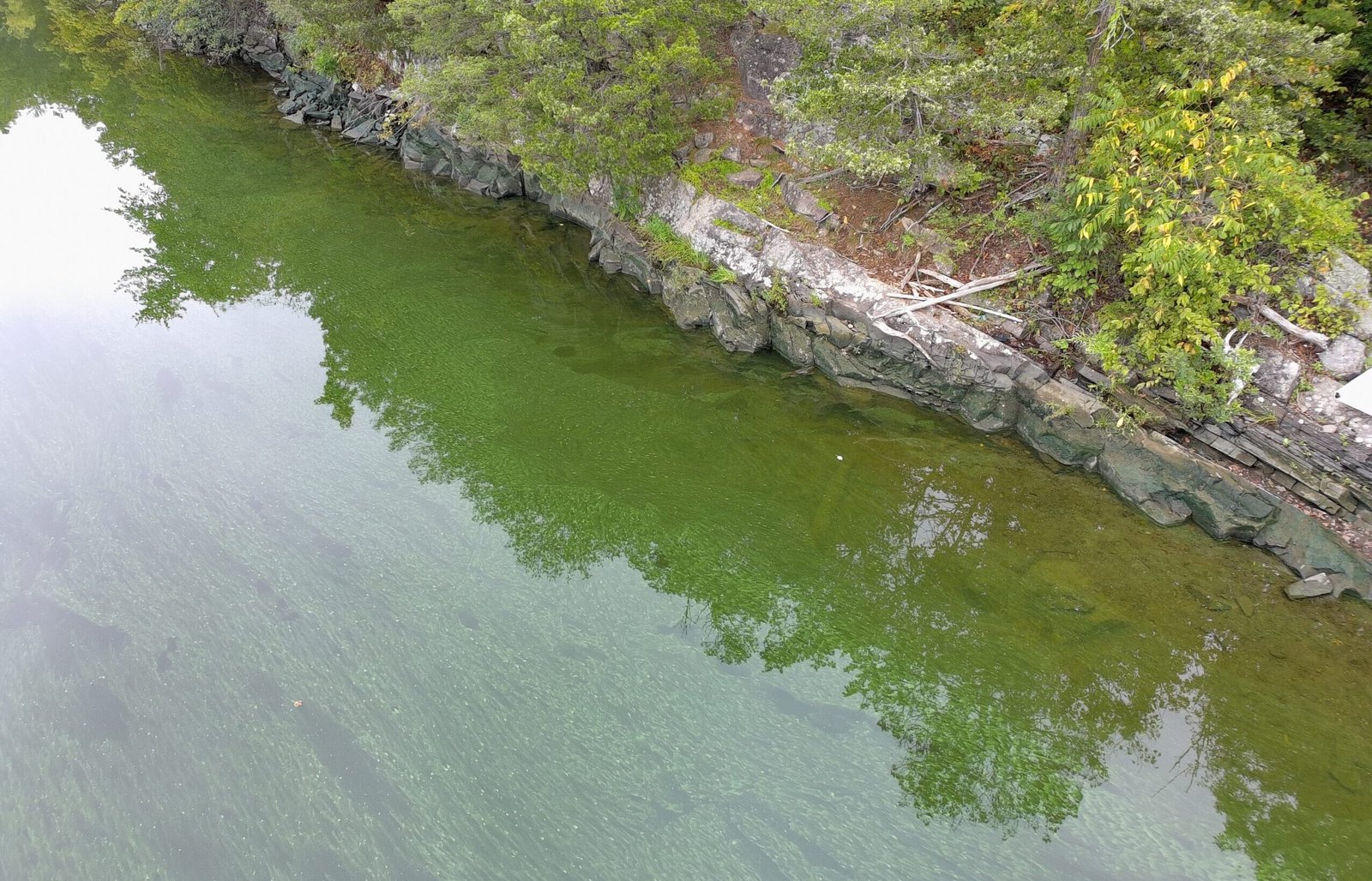
Top-left Duckweed and bottom-left Filamentous Algae are non-toxic look-alikes. Top-right Clear Water is the baseline. Bottom-right Suspicious Scum shows the swirling, paint-like signature of a true cyanobacteria bloom — escalate immediately.
Filamentous Green Algae: Dense, hair-like or cottony green mats floating on the surface or tangled around submerged rocks. Check: when lifted with a stick it stays stringy and thread-like (like wet fabric or green hair) and does not dissolve into the water.
Duckweed & Watermeal: A vibrant green carpet covering stagnant shoreline pools. Check: close up, thousands of tiny oval leaves with hanging rootlets (duckweed); watermeal feels like gritty, abrasive green sand between fingers. These are true flowering plants, not algae.
Tree Pollen: Bright pale-yellow bands across the surface in spring and early summer. Check: an ultra-thin dust-like layer that breaks apart into dry lines when swiped with a paddle — no slimy or gelatinous texture.
Pea Soup Opacity: The water column turns entirely green, blue-green, or brownish-green with visibility dropping to near zero. No individual leaves or hair-like strands present.
Spilled Paint Swirls: Swirling bands of bright green, iridescent blue-green, white, or decaying purple streaks coat the surface — exactly like industrial paint or oil on the river.
Gelatinous Clumps & Globs: Suspended green, irregularly shaped masses or dots floating within the water column or accumulating in thick, frothy scums against downwind docks or shorelines.
What Is NOT a HAB — Look-Alike Photo Gallery
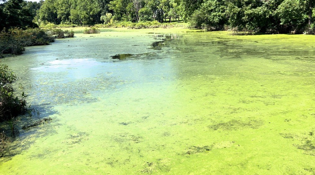
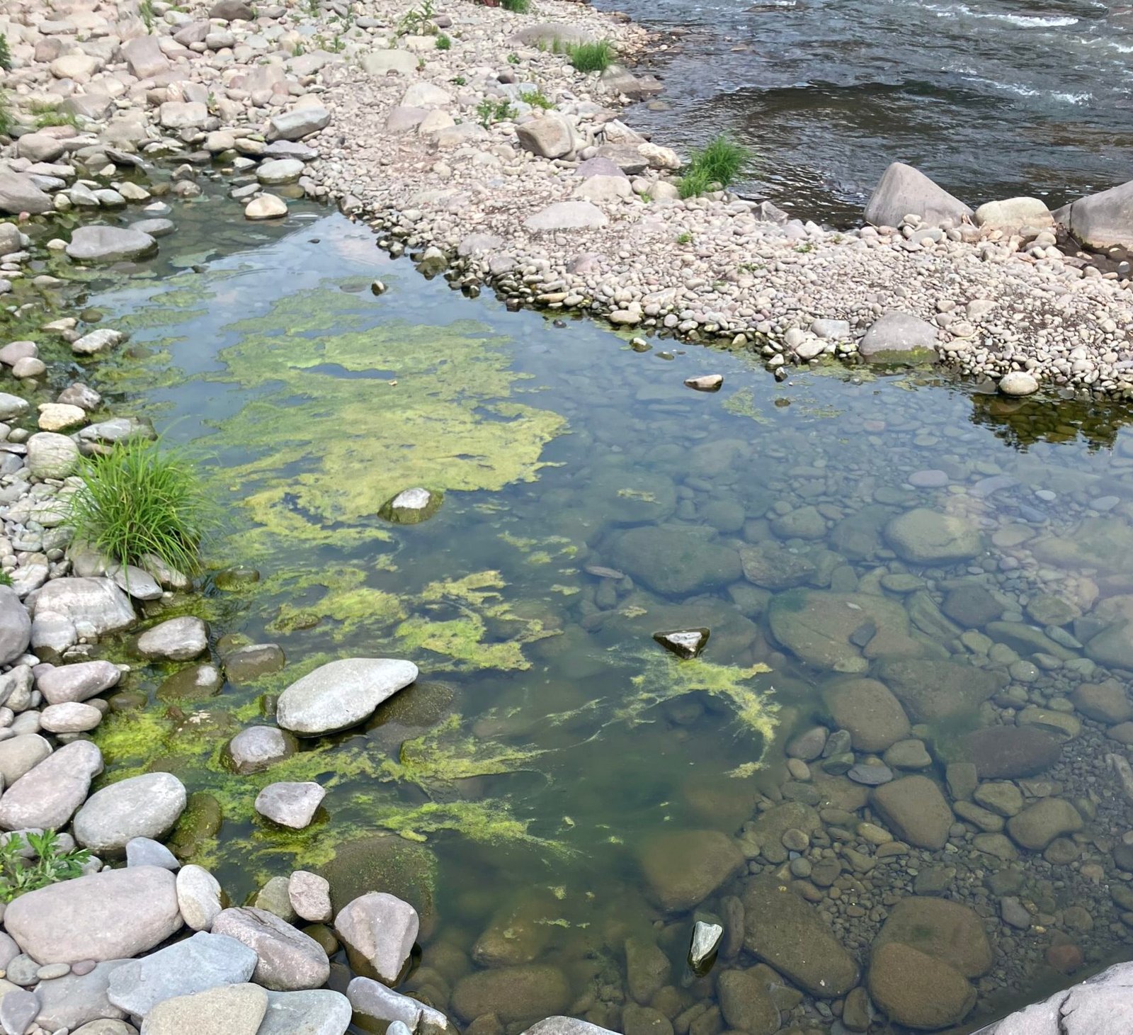
These are not harmful algal blooms. Compare them against the true cyanobacteria indicators and the confirmed bloom photos below before escalating an observation.
Confirmed Wallkill / Sturgeon Pool HAB Photos
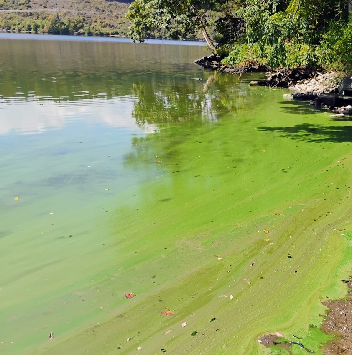
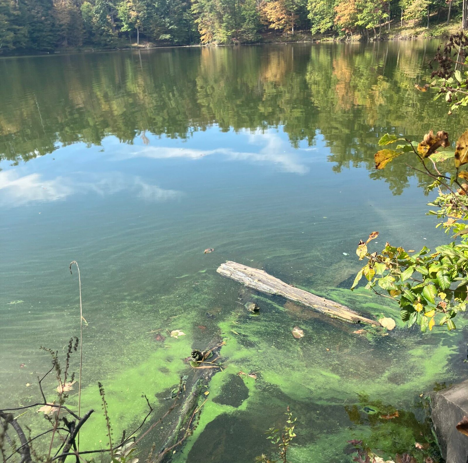
Real WRWA field documentation from the Wallkill corridor. Compare against the visual reference guide above before escalating an observation.
Localized Risk Communication Templates
Reporting & Monitoring Tools
Technical System Architecture
  [ Volunteer Field Inputs ]
              |
              v
  +-----------------------------------------------+
  |          WRWA MASTER DATA GATEWAY             |
  +-----------------------------------------------+
        |                               |
        v (Trained Pro Path)            v (Public Reference Path)
  [ roberthowe.org/         ]    [ roberthowe.org/         ]
  [   reporting-tool/        ]    [   interactive-map...    ]
        |                               |
        +---------------+---------------+
                        |
                        v
              [ NYSDEC NYHABS SYSTEM ]
Volunteer field inputs route through the WRWA Master Data Gateway along a Trained Pro path (validated reporting) and a Public Reference path (spatial verification), both feeding the NYSDEC NYHABS system.
Primary data logging tool for WRWA observers. Enforces form validation rules, requiring users to submit observations before routing payload data to the core archive. If live endpoints drop, the form runs a JavaScript fallback that compiles a pre-filled, schema-compliant email addressed directly to RobHowe94@gmail.com.
An interactive Leaflet.js web application visualizing regional historical datasets — including the 73 verified HAB events logged across Orange and Ulster Counties between 2015 and 2025. It layers the watershed boundary, USGS stream gauge nodes, citizen-science monitoring points, and National Hydrography Dataset (NHD) flowlines onto an interactive base map for spatial context.
Open Interactive Map